SeaJade: Seafloor Earthquake Array - Japan-Canada Cascadia Experiment
Joint project of the Japan Agency for Marine-Earth Science and Technology (JAMSTEC), University of Victoria, Geological Survey of Canada (GSC), and Woods Hole Oceanographic Institution (WHOI)
Funded by JAMSTEC, the Natural Sciences and Engineering Research Council of Canada, GSC, and the U.S. National Science Foundation
Events such as the 2011 Mw9.0 Tohoku earthquake underscore the importance of understanding the seismogenic behaviour of subduction zones and obtaining realistic estimates of the potential size and location of future large earthquakes. The Cascadia subduction zone has the potential to produce such an event, and given its proximity to major cities in both Canada and the U.S. it is very important to public safety to understand the state of the locked zone. Despite significant monitoring efforts over several decades, relatively little was known about seismicity occurring offshore, especially near the megathrust. In order to fill in this knowledge gap, the Seafloor Earthquake Array - Japan-Canada Cascadia Experiment (SeaJade) is a multiyear, two-phase collaborative project to study the seismicity offshore in the northern Cascadia subduction zone, especially near the megathrust, in order to better understand the state of the locked zone.
The first phase of SeaJade involved deployment of 32 short-period ocean bottom seismometers (OBS) from JAMSTEC and 10 broadband OBS from WHOI from CCGS John P. Tully, plus the use of data from the permanent broadband seismometers of the North-East Pacific Time-series Undersea Networked Experiments (NEPTUNE) Canada cabled seafloor observatory (http://www.neptunecanada.ca). These instruments were located primarily on the continental slope. Short-period OBSs were deployed from July to October 2010, and broadband OBS were deployed from July 2010 to July 2011.
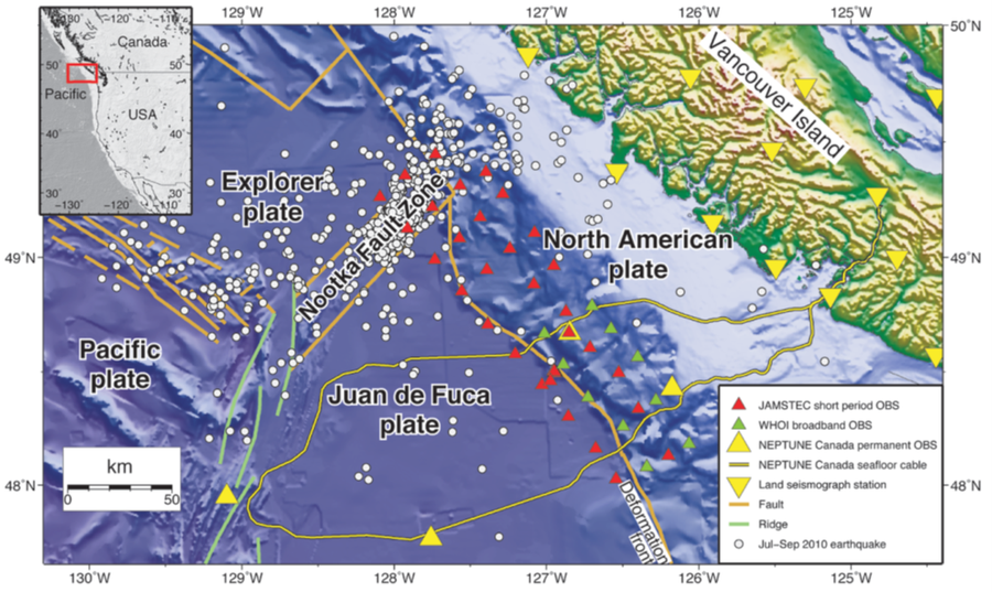
Map showing the monitoring area for the first phase of SeaJade (2010-2011). Coloured triangles indicate locations of OBS on the seafloor and land-based seismometers on Vancouver Island (inverted triangles). The map also shows preliminary earthquake epicenters from the JAMSTEC short-period OBS array (Scherwath et al, 2011).
The short-period OBS array deployed for phase I detected more than 1400 earthquakes over the course of the 3-month deployment, with magnitudes ranging from zero to 3.8. These earthquakes were mainly located in the Nootka fault zone, with only a few tens of events located beneath the continental slope and shelf. Based on the relatively low seismicity rate, researchers felt that the 3-month recording period was too short to adequately determine the overall pattern of seismicity. To more accurately characterize the seismicity in the area, the second phase of SeaJade involved deploying 35 short-period OBS from JAMSTEC in the same area targeted by during Phase I for a period of 10 months. These instruments were deployed from December 2013 to September 2014, again from CCGS John P. Tully.
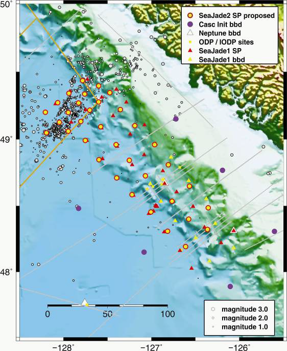
Map showing the locations of OBS deployed during SeaJade Phase II (2013-2014). Red and yellow triangles indicate the location of instruments during Phase I. OBS locations for both phases cover the same region and have similar instrument spacing, except around the Nootka fault zone in the north, where instruments are much more closely spaced during Phase II. Grey dots show the locations of earthquakes detected during Phase I.