OCTOPUS: Ocean-Continent TransitiOn Profile Using Seismics
Dalhousie University Project
Funded by the Natural Sciences and Engineering Research Council of Canada Special Reserach Opportunity fund
The Nova Scotia margin is located in a unique position bounding volcanic margins to its south and non-volcanic margins to its north. Previous studies of the structure during the MARIPROBE Program (1999-2004) and OETR Play Fair Analysis (2009-2011) resulted in margin-normal wide-angle refraction OBS transects that crossed the Scotian offshore in four locations (Figure 1; 3 SMART profiles and 1 OETR profile together with other relevant regional MCS surveys). These profiles show significant variations in rifting style along the margin: (i) a volcanic-type margin in the southwest; (ii) a non-volcanic margin in the centre, with a sharp boundary between highly faulted continental crustal blocks and oceanic crust; and (iii) an extremely amagmatic margin in the northeast, with exposed mantle within the continent-ocean crustal transition and thin oceanic crust seaward. However, without any along-margin continuous coverage it has not been possible to determine the exact location and nature (e.g. gradual/abrupt/complex) of the identified lateral variations in the continent-ocean transition zone.
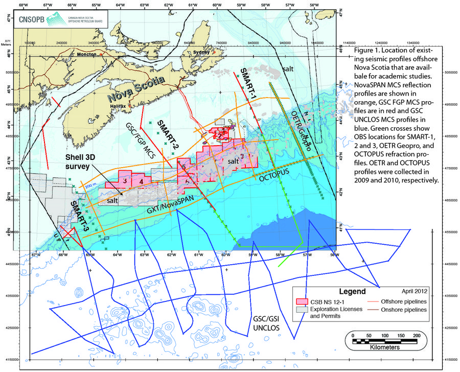
In the Fall of 2010, a margin-parallel OBS profile named OCTOPUS (Ocean-Continent Transition Offshore Profiling Using Seismics) was acquired in water ∼4-km deep using 20 Dal/GSC OBS (Figure 2). The OCTOPUS profile examines, in a continuous manner, the transition from non-volcanic to extreme amagmatic rifting associated with a major change in crustal reflectivity recorded on the GXT Nova Span MCS Line 5100. This profile is about 200 km long, consists of 20 4-C OBS, is coincident with NovaSPAN Profile 5100, and crosses OETR and SMART-1 OBS profiles (Figure 3) . An array consisting of eight air guns (total volume = 68.2 L) towed at 7-m depth was fired at 60-s intervals to produce an average shot spacing of 125 m. The wide-angle data were recorded at a sampling rate of 4 ms . OBS #5 data cannot be analyzed due to a timing error.
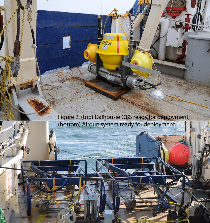
Figure 2.
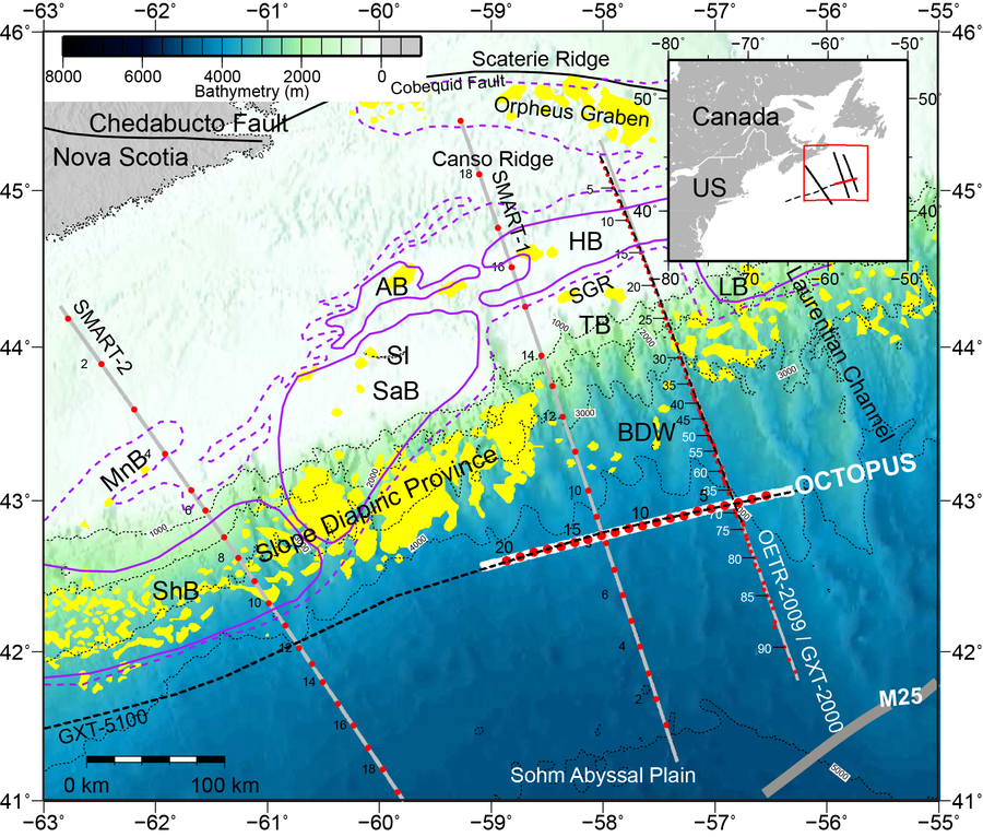
Figure 3. (main) Color bathymetry map showing the location of the OCTOPUS wide-angle seismic profile (thick white line) together with other nearby OBS profiles (thin gray lines) OETR-2009 (Lau et al., 2018) and the SMART-1 and SMART-2 (Funck et al., 2004; Wu et al., 2006). Multichannel seismic profiles GXT-2000 and GXT-5100, coincident with OBS profiles OCTOPUS and OETR-2009, are shown with black dashed lines. Red filled circles are OBS locations numbered sequentially for identification. Purple dashed lines outline the primary salt basin within which purple solid lines define the labeled sedimentary subbasins. Yellow patches are salt. Thick gray line is the M25 magnetic anomaly. SI = Sable Island; MnB = Mohican Subbasin; SaB = Sable Subbasin; ShB = Shelburne Subbasin; AB = Abenaki Subbasin; HB = Huron Subbasin; TB = Tantallon Subbasin; LB = Laurentian Subbasin; BDW = Banquereau Detachment Wedge; SGR = South Griffin Ridge. (inset) The study area (red rectangle) is shown relative to eastern Canada and the United States. The bathymetry is contoured (thin dotted lines) every 1,000 m. The OCTOPUS profile is highlighted in red. OBS = ocean bottom seismometer.
Thus far the vertical geophone and hydrophone data were analyzed using the rayinvr layered velocity modeling/inversion approach (Lau et al., 2019). The results show that the continent-ocean transition at the northeastern Nova Scotia Margin displays highly variable short-wavelength tectonic structures along strike. Widespread serpentinized mantle is found beneath the transitional crust with exhumed serpentinized mantle present only locally.