Evolution of the Juan de Fuca plate from ridge to trench
In collaboration with Lamont-Doherty Earth Observatory of Columbia University and Woods Hole Oceanographic Institution
Funded by the United States National Science Foundation and Natural Sciences and Engineering Research Council of Canada
The evolution of oceanic lithosphere involves incorporation of water into the physical and chemical structure of the crust and shallow mantle through thermally driven fluid circulation, which initiates at the mid-ocean ridge and continues on the ridge flanks long after crustal formation. At subduction zones, water stored and transported with the descending plate is gradually released at depth, strongly influencing subduction zone processes. Cascadia is a young-lithosphere end member of the global subduction system where relatively little hydration of the down-going Juan de Fuca (JdF) plate is expected due to its young age and presumed warm thermal state. However, numerous observations support the abundant presence of water within the subduction zone, suggesting that the JdF plate is significantly hydrated prior to subduction at the trench. At present the state of hydration of the JdF plate is poorly known with few constraints on crustal and upper mantle structure.
In summer 2012, we carried out a 2D controlled source seismic experiment to characterize the evolution of the crust and shallow mantle across complete transects of the JdF plate, from formation at the ridge, through alteration and hydration within the plate interior, to subduction at the Cascadia margin. This was a two ship experiment (R/V Langseth cruise MGL1211 and R/V Oceanus cruise OC1206A) using an 8-km-long MCS streamer and 41 short period OBS instruments. The originally proposed and later collected MCS and OBS profiles are shown in Figure 1.
The specific questions we aim to address are:
- How does the JdF plate evolve from ridge to trench and does significant hydration of the lower crust and upper mantle accompany the now well documented evolution of the uppermost crust as the plate ages?
- What is the state of hydration of the JdF plate at the Cascadia trench, which represents a young and presumed warm end member for subducting plates?
- Do along-trench variations in structure and extent of alteration of the down-going JdF plate contribute to the regional scale variations in structure and seismicity of the Cascadia subduction zone?
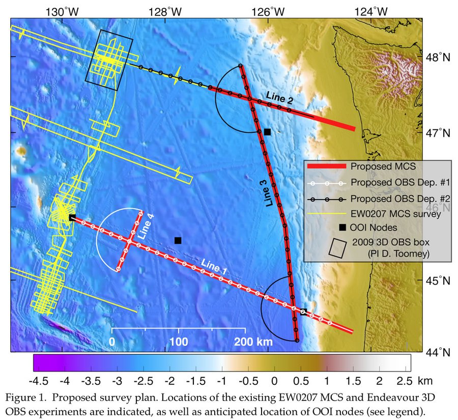
Coincident long-streamer MCS and wide-angle OBS 2D profiles were collected along two ridge-perpendicular transects spanning the full width of the JdF plate and one connecting line targeting along-trench structure. Transects are chosen to provide reference sections of JdF plate structure and evolution offshore two contrasting regions of the Cascadia subduction zone, and spanning the maximum age range of the plate (8-9 Ma). Tomography methods will be used to resolve velocities within the upper 1-2 km of the crust at lateral resolutions of ~2km using streamer data, and lower crust and mantle velocities at lateral resolutions of 10-20 km using OBS data. Reflection images will be used to characterize sediments, igneous basement, faulting, and Moho and sub-Moho structure with an emphasis on faulting in the plate interior and variations in crustal structure along the trench.
Characterization of the structure of the young JdF plate prior to subduction will facilitate comparative studies with other subduction zones where the age of the down-going plate is typically older and plate hydration may be more extensive. The proposed plate transects will connect the now well-imaged JdF ridge with the Cascadia margin at locations of existing major continental seismic profiles across central Oregon and Washington. They will also provide the first continuous ridge-to-trench images ever acquired at any oceanic plate, feasible at the JdF due to the small size of the plate.
Our characterization of the state of the JdF plate prior to subduction bears directly on studies of earthquake hazards in the heavily populated Pacific Northwest where great Cascadia megathrust and damaging intraslab earthquakes have occurred in the historical past. No studies of crustal structure currently exist for the plate interior, which will be crossed by the major infrastructure to be deployed for the Regional Scale Nodes (RSN) of the NSF Ocean Observatories Initiative; our transects will span nodes of the RSN and provide baseline characterization of crustal and uppermost mantle structure for plate-scale studies anticipated with this major program. Our results will also benefit future studies of subduction zone structure, mantle dynamics, and earthquake and volcanic arc processes that are being planned as part of the Cascadia Amphibious Facility, a multi-year deployment of long-period OBSs offshore Cascadia initiated in 2009. This study will form the primary research project for two PhD students, contributing to building our scientific workforce. Results from our program will be used to develop seminars focused on earthquake hazards of the Cascadia subduction zone for the ongoing Earth2Class program for K-12 teachers at Lamont.
The MCS and OBS data analysis is still underway. The first results on determining the subduction bending-related and compaction-related components of the normal faulting imaged across the Juan de Fuca plate have been published in J. Geophys. Res. (Han et al., 2016). Also published in J. Geophys. Res. (Horning et al., 2016) in the same year is the 2D tomographic model of the Juan de Fuca plate from accretion at Axial Seamount to subduction at the Cascadia margin. The most recent publication in Nat. Geosci. (Canales et al., 2017) provides constraints on hydration of the Juan de Fuca slab, which are not only the best yet at the Cascadia margin but are the most complete subducting slab hydration results at any subduction zone globally. One manuscript (Han et al.) is in review for publication in J. Geophys. Res. and at least one more is in late stages of preparation.